How satellite images help to protect forests

Hundreds of satellites orbit the Earth each day and record thousands of images of our planet. These huge quantities of data serve as the basis for various purposes such as weather forecasts and monitoring ocean pollution and the expansion of populated areas. However, the data have to be analyzed and interpreted.
This is where ETH spin-off askEarth comes in: The company facilitates access to satellite images and makes them easily readable, with the focus placed on environmental and climate monitoring.
This technology is coming at a good time as the EU's Deforestation Regulation enters into force at the end of the year. The Regulation requires each company importing commodities to Europe to report on the deforestation risk of its products. Gaetan Petit, co-founder of askEarth, explains, "Companies will have to prove that their products do not result in deforestation, and this will apply retroactively back to 2020."
EU regulation on deforestation-free products (EUDR)
In order to contain global deforestation, the European Union has adopted a regulation on deforestation-free products that enters into force as of 30 December 2024 (Regulation (EU) 2023/1115). It stipulates that relevant commodities, specifically products from timber, soy, cocoa, coffee, rubber, palm oil and cattle, may only be put on the market if they are not connected with deforestation and forest damage.
Making satellite images comprehensible
"Anyone can climb up a hill and take a photo of a forest, perhaps even with a drone. But a completely different impression is created depending on the viewing angle or image section," says Petit. In order to objectify the comparison, the Regulation prescribes the use of satellite images—the satellites always orbit the Earth at the same height and angle. This produces comparable images over a long period every two days.
"This is a perfect starting point for analyzing the data," adds Petit. Together with the European Space Agency, the European Commission has created satellites producing data that is freely accessible to all within the framework of the Copernicus Program.
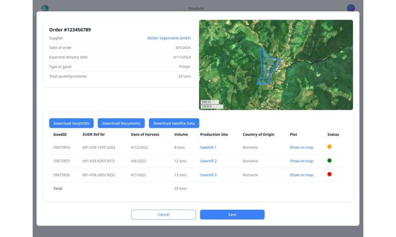
The challenge lies in reading the satellite images. "It isn't easy to analyze the images. Data science is needed in order to filter out the required information," says Petit. Most companies do not have their own data scientists. This is where askEarth comes in. Its software analyzes forestry data and assesses whether there is a deforestation risk. And it does so straight away.
"Sometimes companies need to know immediately whether or not they can accept a timber delivery for processing," says Petit. askEarth therefore integrates its software in the enterprise resource planning (ERP) system that manages and automates business processes and among other things maps the entire supply chain of a company. The solution from askEarth also automatically generates a report that the European Commission can inspect.
Explore the world with askEarth's Explorer
askEarth also offers a publicly accessible tool—the Explorer. Users select a region, various dates and a form of presentation depending on whether they wish to view specific categories such as vegetation, forest fires or forests "in real colors." The Explorer then displays the selected satellite images in a timeline as a video, and changes to vegetation can be easily identified.
askEarth occasionally offers workshops for school classes so that geography teachers can use the Explorer in class. "And of course we also wish to provide private individuals with our full range of products at some point. However, at the moment we're focusing on EUDR and working to acquire further companies as clients," says Petit.
A passion for space
Two of the founders of askEarth, Gaetan Petit and Manuel Gerold, founded their first company four years ago. It was called Space4Impact and among other things it organized events to promote space technologies. "When we noticed the enormous demand among companies for satellite images due to their suitability for Environmental Social Governance (ESG) reporting, we wanted to offer a solution," recalls Petit.
askEarth, which was founded in 2023, has identified the demand for satellite images due to the novel EU Regulation on Deforestation-free supply chains and is now recruiting further clients and staff. "We aim to move in line with policymakers: the Deforestation Regulation is already in place. As soon as another ESG regulation comes, we will develop in this direction," says Petit. askEarth therefore plans to one day offer an entire portfolio of products for climate monitoring and reporting.
Freely available, trustworthy and up-to-date satellite images are a tool for providing comprehensible information and democratizing access to Earth observation data. This is precisely the mission of askEarth. The Explorer is accessible to everyone.
Provided by ETH Zurich